Kto odwiedza Algarve po raz pierwszy, nieuchronnie trafia na Praia da Marinha, Praia de Benagil lub Praia dos Três Irmãos. To niezwykłe plaże — i dlatego właśnie są pełne ludzi w lipcu i sierpniu. Ale Algarve ma ponad 150 uznanych plaż, a dobra część z nich jest praktycznie nieznana szerokiej publiczności.
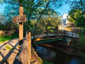
Przez wiele lat eksplorując wybrzeże Algarve, odkryliśmy zatoczki dostępne wyłącznie tunelami wydrążonymi w skale, wyspy barier dostępne tylko łodzią oraz małe plaże w klifach, gdzie można spędzić całego ranka, nie widząc innego kąpielowicza. Ten przewodnik zawiera najlepsze z nich — z praktycznymi wskazówkami dotyczącymi dostępu do każdej z nich.
1. Praia do Carvalho — Tajny tunel Carvoeiro
To jest prawdopodobnie najczęściej fotografowana plaża na Algarve, którą większość ludzi nigdy nie odwiedziła. Położona blisko Carvoeiro, w gminie Lagoa, Praia do Carvalho jest dostępna wyłącznie przez tunel o długości 15 metrów wykuty ręcznie w wapieniach. Wewnątrz tunelu można zaobserwować skamieniałości morskie wtopione w skały — szczegół, który wielu odwiedzających ignoruje, spiesząc się do piasku.
Sama plaża jest mała, z miejscem dla kilkudziesięciu osób, otoczona ochrą klifami i krystalicznie turkusowymi wodami, idealnymi do snorkelingu. W środku sierpnia dostęp przez tunel działa jako naturalny filtr — przybądź przed 9 rano, aby cieszyć się plażą niemal sam.
Jak dojechać: GPS 37.0867, -8.4318. Darmowy parking w Urbanização Clube Atlântico, koniec ulicy Rua de Algarve Clube Atlântico H15. Pieszo, 5 minut szlakiem klifa do wejścia tunelu.
2. Praia do Ninho da Andorinha — Zatoczka, która uciekła Google Maps
Przez lata ta mała zatoczka blisko Albufery była tak tajemnicza, że nie pojawiała się nawet na Google Maps. Dostęp odbywa się przez nieregularny szlak klifa od Hotelu Baía Grande, przejście zajmuje około 10 minut pieszo kamienistym szlakiem. Nie jest to wskazane dla małych dzieci ani osób o ograniczonej mobilności.
Nagrodą jest odosobniona plaża ze złotym drobnym piaskiem, klify obejmujące ją półkolem i szmaragdowe wody. W celach ostrożności, potwierdź warunki dostępu przed wyjazdem — władze lokalne mogą ograniczyć dostęp podczas erozji klifów.
Jak dojechać: Zaparkuj na końcu Rua de João Guita, Albufeira. Podążaj szlakiem klifa na zachód przez 10 minut. Alternatywa: przyjdź kajakiem lub paddleboard z Praia de São Rafael.
3. Praia de Cacela Velha — Wyspa w czasie
Cacela Velha jest jednym z najbardziej autentycznych miejsc na całym Algarve. Zabytkowa wieś z jej wapnowanymi domkami wznosi się nad Ria Formosa, a plaża znajduje się po drugiej stronie ujścia — dostępna pieszo przy niskim poziomie wody lub łodzią. Lokalne kutry rybołówstwa dokonują przejazdu za symboliczną stawkę.
Plaża jest długa i praktycznie pusta, z białym piaskiem i ciepłą wodą z wewnętrznych wód Ria Formosa. Brak infrastruktury — zanieś wodę, jedzenie i kapelusz. Widok na wioskę przy zachodzie słońca jest jednym z najbardziej zapadających w pamięć na wschodnim Algarve.
Jak dojechać: Kieruj się do Cacela Velha, w gminie Vila Real de Santo António. Parking w wiosce, a następnie pieszo do mola z łodziami. Przejazd: 10-15 minut pieszo (niski poziom wody) lub 5 minut łodzią.
4. Praia do Barranquinho — Plaża bez tłumów w Portimão
Zaklęta między klifami w gminie Portimão, ta mała plaża ze złotym piaskiem jest dostępna przez szlak przybrzeżny z Praia de Vau, przejście zajmuje około 20 minut pieszo na nierównym terenie. Brak czuwania oznacza, że rzadko jest tam więcej niż kilkanaście osób.
Wody są krystalicznie czyste i chronione, co stanowi dobrą opcję do nurkowania wolnego. W dni burzliwych wód, fale mogą być silne — niezalecane dla dzieci lub mniej doświadczonych pływaków.
Jak dojechać: Zaparkuj w Praia de Vau i podążaj szlakiem przybrzeżnym na północ wzdłuż klifu. Uważaj na nierówny teren — noszę odpowiednie obuwie.
5. Praia do Zavial — Tajny spot surfingowy Barlavento
Na skrajnym zachodzie Algarve, w gminie Vila do Bispo, Praia do Zavial jest światowej klasy punktem surfingowym, który pozostaje stosunkowo nieznany turystyce masowej. Dostęp odbywa się przez drogę gruntową 4 km z Vila do Bispo, co historycznie zniechęcało rodziny z samochodami o niskim prześwicie.
Ci, którzy podejmują wysiłek, są nagradzani długą i dzika plażą, regularnymi falami i wyluzowaną atmosferą obozowiska surfingowego. Woda jest chłodniejsza niż na południowych zboczach — zanieś kombinezon neoprenowy, jeśli jedziesz w kwietnia lub maju.
6. Praia da Galé Poente — Zapomniana siostra Armação de Pêra
Praia de Armação de Pêra jest jedną z największych i najczęściej odwiedzanych na Algarve. Ale wystarczy przejść 20 minut na zachód wzdłuż klifów, aby dotrzeć do Praia da Galé Poente, zatoczki z znacznie delikatniejszym piaskiem, turkusowymi wodami i ułamkiem ruchu głównej plaży. Bez restauracji, bez wynajęcia parasoli, bez kolejek.
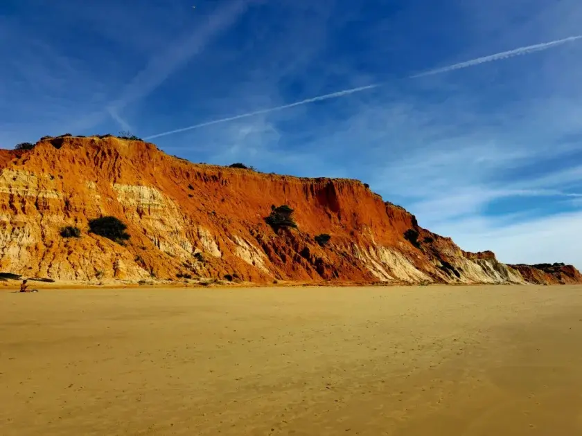
7. Praia do Castelo — Złoty klif między Albufirą a Olhos de Água
Zaklęta w zatoczce złotych klifów między Albufirą a Olhos de Água, ta plaża ma Błękitną Flagę i straż, ale pozostaje znacznie spokojniejsza niż sąsiednie. Dostęp odbywa się drabinami w klifie, co naturalnie ogranicza przepływ odwiedzających. Wody są czyste i chronione przez otaczającą formację skalną.
8. Praia de Almádena — Tajemnica między Luz a Burgau
Między turystycznymi plażami Luz a Burgau, w gminie Lagos, znajduje się prawie nieznana Praia de Almádena. Mała, otoczona niskimi klifami i z łatwo dostępnym parkiem nawet w sierpniu, plaża jest częstowana głównie przez lokalnych mieszkańców. Spokojne wody zatoki czynią ją idealną dla rodzin z małymi dziećmi.
9. Praia de Porto de Mós — Lagos bez tłumów
Porto de Mós znajduje się zaledwie 3 km od centrum Lagos, ale wydaje się zupełnie innym światem. Długa plaża z imponującymi klifami i złotym piaskiem ma skalę, która łatwo absorbuje odwiedzających — nigdy nie wydaje się przepełniona. Parking nad klifami jest darmowy poza sezonem. Bardziej burzliwe wody czynią ją ulubionym surfistów lokalnych.
10. Praia da Ingrina — Zapomniany raj Sagres
15 km od Sagres, Praia da Ingrina jest jedną z najlepiej zachowanych plaż Parku Przyrody Sudoeste Alentejano e Costa Vicentina. Mała zatoczka z białym piaskiem i błękitno-zieloną wodą, z formacjami skalnymi tworzącymi naturalne baseny przy niskim poziomie wody. Dostęp jest asfaltem, parking jest darmowy i jest mała kawiarnia. Woda jest chłodniejsza niż na wschodnim Algarve — w lipcu wynosi około 20-22°C.
11. Praia de Odeceixe — Północna granica Algarve
Technicznie już w Alentejo, Odeceixe jest często uwzględniana w trasach Algarve ze względu na bliskość do Aljezur. Plaża zajmuje dolinę, w której strumień Odeceixe wpada do morza, tworząc unikalną kombinację rzeki i oceanu. Strona rzeczna jest idealna dla dzieci. Zakaz dla samochodów gwarantuje spokój — dostęp jest 2 km pieszo z wioski lub autobusem latem.
12. Praia do Barranco das Canas — Tajemnica lokalna Lagos
Między długim rozciągnięciem Meia Praia a Quinta das Lágrimas, pasek złotego piasku znany jako Barranco das Canas ukrywa się z oczu. 15 minut marszu szlakiem gruntowym z drogi Meia Praia, plaża jest frequentowana niemal wyłącznie przez lokalnych. Widoki na Zatokę Lagos są wspaniałe i atmosfera jest wyluzowana przez cały rok.
Kiedy odwiedzić i jak planować
Najlepszy czas do eksploracji tajnych plaż Algarve to maj, czerwiec i wrzesień. Klimat jest przyjemny, morze jest wystarczająco ciepłe do kąpieli, ceny zakwaterowania są znacznie niższe i większość z tych plaż będzie praktycznie pusta. Lipiec i sierpień są możliwe, ale mniej zalecane — zawsze przybądź przed 9 rano, aby zagwarantować miejsce na mniejszych plażach.
Praktyczne porady dla odwiedzających tajne plaże
- Wynajem samochodu jest istotny — większość nie jest dostępna transportem publicznym
- Zanieś wodę, jedzenie i krem z filtrem — bez infrastruktury wsparcia
- Sprawdź prognozy wiatru i fal przed wyjazdem
- Nigdy nie wchodź do wody, gdy flaga jest czerwona, nawet na plażach bez czuwania
- Nie zostawiaj śmieci — te plaże pozostają tajne częściowo dlatego, że są szanowane przez odwiedzających
- Na plażach bez ratownika, poinformuj kogoś, dokąd idziesz i zaplanuj czas powrotu
FAQ — Tajne plaże Algarve
Jaka jest najtajniejsza plaża na Algarve?
Praia do Ninho da Andorinha w Albuferze jest często wymieniana jako najtajniejsza plaża na Algarve — przez lata nie pojawiała się nawet na Google Maps. Dostęp wymaga 10-minutowego spaceru nieregularnym szlakiem klifa, co naturalnie ogranicza liczbę odwiedzających.
Czy mogę odwiedzić tajne plaże Algarve z dziećmi?
To zależy od plaży. Praia de Almádena (Lagos), Praia da Ingrina (Sagres) i Praia de Cacela Velha (Vila Real de Santo António) są odpowiednie dla rodzin z małymi dziećmi. Praia do Ninho da Andorinha i Praia do Barranquinho nie są zalecane ze względu na trudny dostęp i brak czuwania.
Kiedy jest najlepszy czas do odwiedzenia mało znanych plaż na Algarve?
Maj, czerwiec i wrzesień to idealne miesiące: stabilny klimat, ciepłe morze i znacznie mniej ludzi niż w lipcu i sierpniu. W czerwcu temperatura wody na tych plażach wynosi około 19-21°C — chłodno, ale całkowicie odpowiednie do kąpieli.
Czy jest bezpiecznie pływać na plażach bez ratownika?
Jest to możliwe, ale wymaga większej ostrożności. Sprawdź prognozę fal i wiatru przed wyjazdem, zawsze pływaj blisko innych kąpielowiczów, jeśli to możliwe, i unikaj wchodzenia do wody samotnie w dni burzliwych wód. Nawet doświadczeni pływacy powinni szanować warunki Atlantyku.
Jak dotrzeć do tajnych plaż Algarve bez samochodu?
Większość z tych plaż nie jest dostępna regularnym transportem publicznym. Kilka wyjątków: Cacela Velha ma autobusy z gminy Vila Real de Santo António; Odeceixe ma sezonową obsługę autobusową latem. W pozostałych przypadkach wynajem samochodu lub roweru to najlepsze alternatywy.
Podsumowanie
Algarve ma więcej do zaoferowania niż sugerują jego turyści plakaty. Za pełnymi w sierpniu plażami kryje się kilkadziesiąt zatoczek, wysp i małych plaż w klifach, które zachowują to, czym zawsze było Algarve: dzike, autentyczne i niezwykle piękne. Dobrze planuj, szanuj ścieżki i środowisko, i zanieś aparat — te plaże zasługują na bycie dzielonymi, ale ze świadomością.
Zapoznaj się z naszym pełnym katalogiem plaż Algarve i przejrzyj przewodnik najlepszych plaż Algarve, aby porównać z bardziej popularnymi opcjami. Jeśli podobają ci się krajobrazy dzikiego wybrzeża, nie przegap naszego artykułu o Costa Vicentina.