Guias de Viagem

Barlavento vs Sotavento : Quel Côté de l'Algarve Choisir pour vos Vacances?

Rui Costa Contenu vérifié

L'Algarve se divise en deux mondes distincts : le Barlavento à l'ouest, avec des falaises spectaculaires, des grottes marines et des vagues pour le surf ; et le Sotavento à l'est, avec des lagunes, des îles-barrières et des eaux calmes parfaites pour les familles. Ce guide comparatif vous aide à choisir le bon côté selon votre profil de vacancier.

Quiconque planifie des vacances en Algarve se retrouve tôt ou tard face à un choix qui semble simple mais qui fait toute la différence : aller au Barlavento (le côté ouest) ou au Sotavento (le côté est) ? La réponse change selon le profil du voyageur — et la différence entre les deux côtés est plus grande que la plupart des gens ne l'imaginent en regardant une carte.

Résumé rapide : Le Barlavento (Lagos, Portimão, Albufeira, Sagres, Aljezur) est l'Algarve des falaises dorées, des grottes marines, des plages cachées entre les rochers et des vagues atlantiques pour les surfeurs. Le Sotavento (Faro, Olhão, Tavira, Vila Real de Santo António) est l'Algarve des lagunes, des îles-barrières, des eaux calmes et chaudes, et des fruits de mer de la Ria Formosa.

La Division Géographique : Que sont le Barlavento et le Sotavento ?

Le Barlavento Algarvio couvre les municipalités occidentales : Vila do Bispo (où se trouvent Sagres et le Cap Saint-Vincent), Lagos, Portimão, Lagoa (où se trouvent la Praia da Marinha et Carvoeiro), Silves, Albufeira, Monchique et Aljezur.

Le Sotavento Algarvio couvre les municipalités orientales : Loulé, Faro, Olhão, Tavira, Castro Marim, Vila Real de Santo António et Alcoutim. Cette zone est dominée par la Ria Formosa, l'un des parcs naturels les plus importants du Portugal — un réseau de lagunes, de marais salants et d'îles-barrières s'étendant sur plus de 60 km de côte.

Paysage et Type de Plages : La Différence la Plus Visible

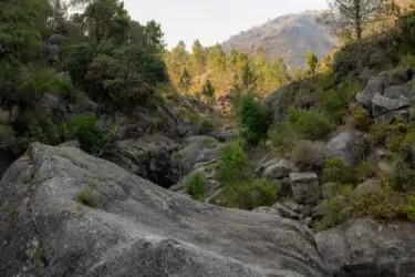
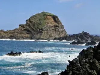
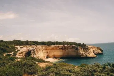
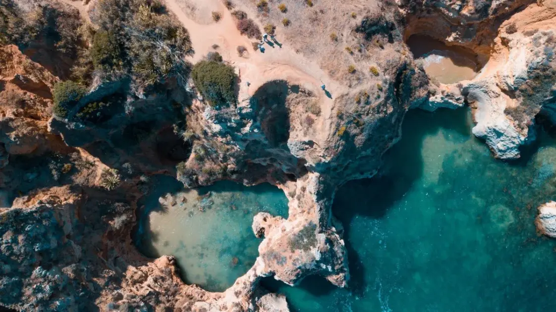
Barlavento : Falaises, Grottes et Criques Cachées

Le paysage du Barlavento est dominé par des falaises de calcaire et de grès sculptées pendant des millénaires par l'érosion atlantique. La Grotte de Benagil, à Lagoa, est peut-être le symbole le plus reconnaissable de ce côté de l'Algarve : une grotte accessible en bateau ou à la nage, avec une ouverture circulaire dans le plafond qui projette de la lumière sur une minuscule plage intérieure.

Sotavento : Lagunes, Îles et Sables Infinis

Le Sotavento a un paysage radicalement différent. Les plages des îles-barrières (Ilha de Tavira, Ilha de Armona, Ilha da Culatra, Ilha de Faro) ne sont accessibles qu'en ferry. Tavira est l'une des plus belles villes de l'Algarve — consultez notre guide complet de Tavira et la Ria Formosa.

Température de l'Eau et Conditions de Baignade

Le Barlavento est exposé directement à l'Océan Atlantique. Le phénomène d'upwelling côtier est particulièrement intense le long de la côte ouest — les plages du Barlavento ont de l'eau qui dépasse rarement 20–22°C même en plein été. Le Sotavento bénéficie d'un effet de "réchauffement de la lagune" unique : les eaux du côté lagonaire des îles-barrières peuvent atteindre 26–28°C en juillet et août.

Mois Barlavento (Lagos/Albufeira) Sotavento (Tavira/Monte Gordo)
Juin19–21°C21–23°C
Juillet20–22°C23–25°C
Août21–23°C24–26°C (lagonaire : jusqu'à 28°C)
Septembre21–23°C23–25°C
Octobre19–21°C21–23°C

Pour les Familles avec Enfants : Quel est le Bon Côté ?

La réponse est claire : le Sotavento présente des avantages significatifs pour les familles avec de jeunes enfants — eau plus chaude, vagues plus petites, moins de courants et des plages plus vastes. Le Sotavento est clairement le meilleur choix pour les familles.

Gastronomie : Différences entre les Deux Côtés

Le Barlavento est le territoire de la cataplana — la marmite en cuivre typique de l'Algarve. Le Sotavento est le territoire des fruits de mer de la Ria Formosa : huîtres, palourdes, coques et couteaux de mer, tous provenant directement des bancs de la lagune.

FAQ — Barlavento vs Sotavento Algarve

Quelle est la principale différence entre le Barlavento et le Sotavento de l'Algarve ?

Le Barlavento (côté ouest) se caractérise par des falaises, des plages entre rochers, des grottes marines, des vagues atlantiques plus fortes et une eau légèrement plus fraîche. Le Sotavento (côté est) est dominé par la Ria Formosa, avec des îles-barrières, des lagunes, de vastes plages de sable, une eau plus chaude et calme, et un caractère plus authentique.

Quel est le meilleur côté de l'Algarve pour aller en septembre ?

Septembre est excellent pour tout l'Algarve. Le Sotavento en septembre peut offrir la meilleure combinaison : beau temps, eau chaude (23–25°C) et moins de touristes.

Est-il moins cher de séjourner dans le Sotavento que dans le Barlavento ?

En général, oui. Le Sotavento tend à proposer des hébergements 20–40% moins chers que les zones équivalentes du Barlavento en haute saison.

Conclusion

L'Algarve n'est pas une seule destination — c'est deux destinations en une, séparées par quelques dizaines de kilomètres mais avec des personnalités très distinctes. Explorez notre annuaire des plages de l'Algarve et notre guide des meilleures plages de l'Algarve.

Sources et références

R

Rui Costa

Contributeur de l'équipe éditoriale de Praias de Portugal. Spécialisé dans le tourisme balnéaire et les sports nautiques au Portugal.


Articles Connexes

Guias de Viagem

Praias Fluviais do Rio Mondego: Guia Completo 2026 (Kayak, Penacova e Coimbra)

Descubra as melhores praias fluviais do Rio Mondego em 2026: Reconquinho e Palheiros/Zorro (Bandeira Azul), percurso de kayak Penacova–Coimbra, fauna ripícola, como chegar e onde comer.

04 Jun 2026 par Rui Costa
Guias de Viagem

Tavira: Guia Completo das Praias, Ilhas e O Que Fazer em 2026

Guia completo de Tavira 2026: praias da Ilha de Tavira, Praia do Barril (Cemitério das Âncoras), Cabanas, Terra Estreita, centro histórico, Santa Luzia (polvo), Cacela Velha, kayak na Ria Formosa, gastronomia e como chegar.

03 Jun 2026 par Rui Costa
Guias de Viagem

Praia de Monte Clérigo : Guide Complet de la Meilleure Plage d'Europe 2026

<div class="key-takeaway" style="background:#f0f7ff;border-left:4px solid #0070c0;padding:16px 20px;margin-bottom:32px;border-radius:4px;"> <strong>Key Takeaway:</strong> Praia de Monte Clérigo in Aljezur was named <strong>Europe's Best Beach 2026</strong> by European Best Destinations — beating 30 finalists from across the continent. Set within the Southwest Alentejo and Vicentine Coast Natural Park, this 700-metre stretch of Atlantic sand combines surf waves, natural rock pools, intact dunes and an atmosphere that has remained untouched by mass tourism. GPS: 37.3408, -8.8531. Located 8 km from Aljezur and 30 km from Lagos. Best time to visit: June to September. </div> <h2>Europe's Best Beach 2026 Is in Portugal — on the Wild Vicentine Coast</h2> <p>On 27 May 2026, the <strong>European Best Destinations</strong> organisation revealed its annual ranking of Europe's finest beaches — and for the first time in the award's history, a Portuguese beach claimed the top spot. <strong>Praia de Monte Clérigo</strong>, in Aljezur, beat 29 finalists from across the continent, including Greek, Italian and Croatian beaches that have historically dominated the rankings, to become officially recognised as <strong>Europe's Best Beach 2026</strong>.</p> <p>For those who already know the Vicentine Coast, the recognition comes as no surprise. After visiting this coastline repeatedly over the years, we have consistently been struck by how Monte Clérigo manages to offer everything — surf, nature, authenticity, minimal but sufficient facilities — without yielding to the mass-tourism pressure that has transformed so many beaches along Portugal's southern shore. The secret has been well kept. Until now.</p> <p>This guide covers everything you need to know to visit Europe's best beach in 2026: how to get there, when to go, what to do, where to eat, nearby beaches, and the criteria that earned Monte Clérigo its historic title.</p> <h2>Why Monte Clérigo Was Named Europe's Best Beach</h2> <p>The European Best Destinations selection process follows a rigorous two-stage methodology. In the first stage, the editorial team evaluates hundreds of European beaches against a comprehensive set of criteria: natural beauty, water quality, accessibility, family-friendliness, authenticity, available activities, environmental preservation, beach services, quality of nearby accommodation and overall atmosphere. This analysis yields the 30 finalists submitted to an international vote of travellers and tourism specialists.</p> <p>Monte Clérigo achieved the highest overall score on the criterion that carried the most weight in the final evaluation: <strong>environmental preservation combined with authentic visitor experience</strong>. Located within the <strong>Southwest Alentejo and Vicentine Coast Natural Park (PNSACV)</strong>, the beach is protected by legislation that prohibits construction on the front line and severely limits tourist development in the surrounding area. The result is a beach that, in the 21st century, still looks as Portuguese beaches looked 40 years ago: free, wild, integrated into the natural landscape.</p> <p>Second place went to <strong>Voutoumi Beach</strong> on Antipaxos in Greece — named the most visually beautiful beach on the continent by evaluators. Third and fourth went to Greek beaches <strong>Fteri on Kefalonia</strong> and <strong>Elafonisi in Crete</strong> — three extraordinary destinations that nonetheless finished behind the quiet Vicentine Coast.</p> <h2>Where Is Praia de Monte Clérigo</h2> <p>Praia de Monte Clérigo is located in the <strong>municipality of Aljezur</strong>, in the far northwest of the Algarve region, fully within the <strong>Vicentine Coast</strong>. GPS coordinates: <strong>37.3408, -8.8531</strong>. The hamlet of Monte Clérigo sits directly above the beach, with whitewashed houses cascading down the hillside towards the shore.</p> <p>Administratively, it falls within the <strong>Southwest Alentejo and Vicentine Coast Natural Park</strong>, the largest protected coastal area in Western Europe, stretching over 110 km of coastline from Burgau (Algarve) to Santiago do Cacém (Alentejo). This legal protection is, in large part, responsible for the beach's exceptional state of conservation.</p> <h3>Distances and Reference Points</h3> <ul> <li><strong>Aljezur town:</strong> 8 km — access follows the N120 from Aljezur</li> <li><strong>Lagos:</strong> 30 km south — the nearest city with full services</li> <li><strong>Portimão:</strong> 45 km southeast</li> <li><strong>Lisbon:</strong> 265 km north via A2 + A22</li> <li><strong>Faro Airport:</strong> 95 km east</li> </ul> <h2>How to Get to Praia de Monte Clérigo</h2> <p>The Vicentine Coast is, by nature, a destination that requires logistical planning — and Monte Clérigo is no exception. The beach is not within walking distance of any town, so the vast majority of visitors arrive by car.</p> <h3>By Car</h3> <p>The most direct route from <strong>Lisbon</strong> is via the A2 motorway to Grândola Sul, then the EN393 heading south, or alternatively the A22 (Via do Infante) to Lagos, then the N120 north to Aljezur. From Aljezur, follow signs for "Praia de Monte Clérigo". Total distance: <strong>265 km, approximately 2h45 to 3h</strong>, depending on summer traffic on the A22.</p> <p>From <strong>Lagos</strong>, take the N120 north for 30 km — approximately <strong>30 to 35 minutes</strong> along a winding but well-signposted road.</p> <p>A paid car park operates at the beach entrance (<strong>free from October to May; paid June to September</strong>, approximately €2–3 per hour in peak season). On summer weekends — especially in 2026 following the European award — the car park can fill before 10am. We recommend arriving before 9:30am or visiting on weekdays.</p> <h3>By Bus</h3> <p>The <strong>Lisbon to Aljezur</strong> route is served by <strong>Rede Expressos</strong>, departing from Sete Rios bus station. The journey takes approximately <strong>3h40</strong>, with tickets from <strong>€4</strong> when booked in advance. From Aljezur to the beach itself, a local taxi (~€8–10) or bicycle is required as no bus route reaches the shore directly.</p> <p>From <strong>Lagos</strong>, <strong>Vamus — Algarve Transports</strong> operates a service to Aljezur taking approximately <strong>41 minutes</strong>. Check timetables at vamus.pt as departures are limited (typically 3–4 per day in the bathing season).</p> <p>Car-free access is possible but requires planning. For a day trip, the combination of Rede Expressos and local taxi works well. For longer stays, consider hiring a car in Faro or Lagos.</p> <h2>The Beach: Features and Atmosphere</h2> <p>Monte Clérigo stretches approximately <strong>700 metres in length</strong> and between 40 to 80 metres in width depending on the tide. The sand is golden with a medium grain — not the fine white sand of the southern Algarve, but the textured Atlantic sand that surfers appreciate for warm-up on land. The beach faces <strong>west</strong>, delivering sunsets directly over the ocean — one of the most sought-after spectacles in the region.</p> <p>To the north, a small stream reaches the beach beside the dunes, creating a sheltered area of mixed, calmer water that families with young children favour when Atlantic waves feel too powerful. To the south, low cliffs and rock formations frame the beach, revealing natural tidal pools at low tide that shelter anemones, crabs, small fish and sea urchins.</p> <p>The hamlet of Monte Clérigo — a small village of fewer than 200 permanent residents — sits immediately above the beach, with two or three restaurants and a surf school. This human scale is precisely what keeps Monte Clérigo different: no four-star hotels on the front line, no loud music bars, no jet-skis circling the shore. What exists is a beach that still feels as if it belongs to nature, with visitors integrating into it rather than dominating it.</p> <h3>Beach Features at a Glance</h3> <table style="width:100%;border-collapse:collapse;margin:16px 0;"> <thead><tr style="background:#0070c0;color:#fff;"> <th style="padding:8px;text-align:left;">Feature</th><th style="padding:8px;text-align:left;">Detail</th> </tr></thead> <tbody> <tr style="background:#f5f5f5;"><td style="padding:8px;">Length</td><td style="padding:8px;">~700 metres</td></tr> <tr><td style="padding:8px;">Orientation</td><td style="padding:8px;">West (sunset over the ocean)</td></tr> <tr style="background:#f5f5f5;"><td style="padding:8px;">Sand type</td><td style="padding:8px;">Golden, medium grain</td></tr> <tr><td style="padding:8px;">Blue Flag</td><td style="padding:8px;">Yes (2026)</td></tr> <tr style="background:#f5f5f5;"><td style="padding:8px;">Lifeguards</td><td style="padding:8px;">July to September</td></tr> <tr><td style="padding:8px;">Parking</td><td style="padding:8px;">Paid Jun–Sep; free rest of year</td></tr> <tr style="background:#f5f5f5;"><td style="padding:8px;">WC and showers</td><td style="padding:8px;">Yes</td></tr> <tr><td style="padding:8px;">Bar / Restaurant</td><td style="padding:8px;">Yes (hamlet directly above beach)</td></tr> <tr style="background:#f5f5f5;"><td style="padding:8px;">Accessibility</td><td style="padding:8px;">Wooden boardwalk to the shore</td></tr> <tr><td style="padding:8px;">Surf</td><td style="padding:8px;">All levels</td></tr> <tr style="background:#f5f5f5;"><td style="padding:8px;">Families</td><td style="padding:8px;">Excellent (calm stream area)</td></tr> <tr><td style="padding:8px;">Natural pools</td><td style="padding:8px;">Visible at low tide (south end)</td></tr> <tr style="background:#f5f5f5;"><td style="padding:8px;">Legal protection</td><td style="padding:8px;">PNSACV — Natural Park</td></tr> <tr><td style="padding:8px;">GPS</td><td style="padding:8px;">37.3408, -8.8531</td></tr> </tbody> </table> <h2>Surfing and Activities at Monte Clérigo</h2> <p>The Vicentine Coast is one of the most respected surf destinations on the Iberian Peninsula, and Monte Clérigo is one of its most versatile beaches. The Atlantic swells that reach this coast travel unobstructed from the North Atlantic, guaranteeing consistency year-round — but it is between September and April that experienced surfers find optimal conditions.</p> <h3>Surfing for All Levels</h3> <p>Monte Clérigo is considered suitable for <strong>beginners and intermediate surfers</strong> most of the time. Waves form over a sandy bottom with a relatively predictable break pattern, and the northern section (near the stream) offers smaller, more widely spaced waves ideal for first steps. On days with larger swell generated by North Atlantic depressions between October and March, the beach becomes more demanding and is best left to experienced surfers.</p> <p><strong>Boa Onda Surf School</strong> runs group lessons on the beach during the bathing season (June to September), priced at approximately <strong>€30–40 for a 2-hour group session</strong>. <strong>Aljezur Surf School</strong> also divides its operation between Monte Clérigo and the nearby Arrifana, rotating according to daily conditions. Both schools offer board and wetsuit hire.</p> <p>For non-surfers, the <strong>natural tidal pools</strong> on the rocks at the south end of the beach are an extraordinary alternative. At low tide, natural lagoons of clear water form, sheltered from the waves, where marine life — starfish, crabs, shrimps, polyps, small rock fish — can be observed at eye level. It is free snorkelling with no equipment other than a simple dive mask.</p> <p>The <strong>Rota Vicentina</strong> coastal trail passes directly through Monte Clérigo. The most popular section links the beach to <strong>Praia da Amoreira</strong> to the north (15 minutes on foot along the cliffs and dunes) and descends to <strong>Praia da Arrifana</strong> to the south (60 to 90 minutes). The route delivers ocean views and heathland scenery that are difficult to match anywhere else in Portugal.</p> <h2>Nearby Beaches: The Northern Vicentine Coast Corridor</h2> <p>One of the reasons the Aljezur region captivates visitors who discover it is the density of exceptional beaches within a 15 to 20 km radius. Monte Clérigo sits at the natural centre of a corridor that includes some of Portugal's most impressive stretches of coast.</p> <h3>Praia da Amoreira (5 min by car / 15 min on foot)</h3> <p><strong>Praia da Amoreira</strong> lies immediately north of Monte Clérigo — walkable along the coast in 15 minutes or reachable by car in 5. It is a long beach with a stream creating a shallow, warm lagoon (<strong>perfect for very young children</strong>) and full Atlantic waves in the more exposed section for surfers. The dune landscape covered in low-growing vegetation and the near-total absence of infrastructure make Amoreira one of the most photogenic beaches on the Vicentine Coast. <strong>GPS: 37.3611, -8.8632</strong></p> <h3>Praia da Arrifana (15 min by car)</h3> <p><strong>Praia da Arrifana</strong> is the most famous beach in the Aljezur municipality among the surf community. Sheltered by a headland that creates a semi-enclosed bay, Arrifana has a characteristic <strong>left-hand wave</strong> that works with northwest swell and is highly regarded by intermediate and advanced surfers. The beach has slightly more infrastructure than Monte Clérigo — more restaurants, an established surf school — but retains the Vicentine atmosphere. The ruins of <strong>Arrifana Fortress</strong> at the top of the headland are a must-visit for the view over the bay. <strong>GPS: 37.2897, -8.8615</strong></p> <h3>Praia de Odeceixe (25 min by car)</h3> <p><strong>Praia de Odeceixe</strong> is a Vicentine Coast classic: the Seixe stream divides the beach in two, creating on the river side a completely calm and warm zone (26–28°C in August), and on the ocean side perfect surf and bodyboard waves. It is the only beach in Portugal simultaneously located in the Algarve (south bank) and the Alentejo (north bank). A destination in its own right, 25 minutes by car from Monte Clérigo. <strong>GPS: 37.4282, -8.7920</strong></p> <h3>Praia de Bordeira / Carrapateira (30 min by car)</h3> <p>To the south of Monte Clérigo, <strong>Praia da Bordeira</strong> near Carrapateira is one of the largest deserted beaches on the Vicentine Coast, with over 2 km of monumental dune formations and powerful waves. It is a beach for those seeking the full force of the Atlantic — no beach infrastructure, dirt track access roads, and surfers who travel from across Portugal on days of good swell. To the north of Bordeira lies <strong>Praia do Amado</strong>, considered one of the finest surf beaches on the Vicentine Coast and host to national surf championships. <strong>GPS Bordeira: 37.1912, -8.9041</strong></p> <h2>Food and Where to Eat Near Monte Clérigo</h2> <p>The gastronomy of the Aljezur region has distinctive characteristics that set it apart from the rest of the Algarve. Positioned at the border between the Algarve and the Alentejo, in a predominantly rural municipality, local ingredients carry an authenticity that restaurants in more touristic areas rarely replicate.</p> <h3>In the Hamlet of Monte Clérigo</h3> <p>The hamlet itself has two or three eating establishments facing the beach, with simple menus of freshly grilled fish, sandwiches and petiscos. These are informal spaces with sea-view terraces, well suited to a post-beach lunch. On summer weekends in 2026 — with the elevated footfall expected following the European award — arriving early or booking ahead is strongly recommended.</p> <h3>In Aljezur (8 km)</h3> <p>The town of Aljezur offers a wider restaurant selection. A highlight not to miss is the <strong>Aljezur sweet potato</strong> — a product with Protected Geographical Indication (PGI) that exists only on this coast: a pink-skinned, gently sweet variety with a texture found nowhere else in Portugal. It appears roasted, in soups or as an accompaniment to grilled fish in many restaurants in town. Another regional speciality worth seeking out is <strong>cataplana de percebes</strong> — the barnacles harvested from the Vicentine Coast rocks are of exceptional quality, with a more intense iodine-and-sea flavour than those found on the southern Algarve.</p> <h2>Best Time to Visit Monte Clérigo</h2> <p>The most common question from visitors discovering Monte Clérigo is simple: when should I go? The answer depends on what you are looking for.</p> <table style="width:100%;border-collapse:collapse;margin:16px 0;"> <thead><tr style="background:#0070c0;color:#fff;"> <th style="padding:8px;">Month</th><th style="padding:8px;">Air temp</th><th style="padding:8px;">Sea temp</th><th style="padding:8px;">Waves</th><th style="padding:8px;">Crowds</th> </tr></thead> <tbody> <tr style="background:#f5f5f5;"><td style="padding:8px;">May</td><td style="padding:8px;">18–22°C</td><td style="padding:8px;">16–17°C</td><td style="padding:8px;">Medium</td><td style="padding:8px;">Low</td></tr> <tr><td style="padding:8px;"><strong>June</strong></td><td style="padding:8px;"><strong>22–26°C</strong></td><td style="padding:8px;"><strong>17–19°C</strong></td><td style="padding:8px;">Small–medium</td><td style="padding:8px;">Medium</td></tr> <tr style="background:#f5f5f5;"><td style="padding:8px;">July</td><td style="padding:8px;">25–28°C</td><td style="padding:8px;">19–21°C</td><td style="padding:8px;">Small</td><td style="padding:8px;">High</td></tr> <tr><td style="padding:8px;">August</td><td style="padding:8px;">26–30°C</td><td style="padding:8px;">19–22°C</td><td style="padding:8px;">Small</td><td style="padding:8px;">Very high</td></tr> <tr style="background:#f5f5f5;"><td style="padding:8px;"><strong>September</strong></td><td style="padding:8px;"><strong>23–27°C</strong></td><td style="padding:8px;"><strong>20–22°C</strong></td><td style="padding:8px;">Medium–large</td><td style="padding:8px;">Medium</td></tr> <tr><td style="padding:8px;">October</td><td style="padding:8px;">19–23°C</td><td style="padding:8px;">19–21°C</td><td style="padding:8px;">Large</td><td style="padding:8px;">Low</td></tr> <tr style="background:#f5f5f5;"><td style="padding:8px;">Nov–Mar</td><td style="padding:8px;">12–17°C</td><td style="padding:8px;">14–17°C</td><td style="padding:8px;">Very large</td><td style="padding:8px;">Minimal</td></tr> </tbody> </table> <p>Our unequivocal recommendation is <strong>June and September</strong>. In June, crowds have yet to build significantly, the weather is stable and warm, and the golden late-afternoon light turns sunsets cinematically beautiful. In September, water temperatures reach their annual peak, visitor numbers fall after the end of school holidays, and the first autumn swells begin to arrive — making it the best month of the year for those wanting to combine swimming, surfing and hiking in peace.</p> <p>August is the most in-demand month, but in 2026 the pressure may be exceptionally high due to the European award. Those who can should avoid August or compensate with very early or very late arrivals.</p> <h2>Practical Tips for Visiting Monte Clérigo in 2026</h2> <ul> <li><strong>Arrive before 9:30am in July and August:</strong> The car park fills quickly on summer weekends. In 2026, with the additional visibility from the European award, demand is expected to exceed previous years significantly.</li> <li><strong>Use high-factor sun protection:</strong> The Vicentine Coast's northerly winds create a feeling of coolness that masks the intensity of the sun. UV levels are high from May to September even under partial cloud cover.</li> <li><strong>Wind is a fact of life:</strong> Northerly winds are the norm on this coast. They carry sand and can be uncomfortable on the beach on windier days. Bring a windbreak or choose the south end of the beach, which is more sheltered by the cliffs.</li> <li><strong>Check the tide for the rock pools:</strong> Consult the tide tables before visiting. The natural pools at the south end are accessible and safe only in the 2 hours before and after low tide. The "Tides Near Me" app or Portugal's Hydrographic Institute (hidrografico.pt) have accurate predictions.</li> <li><strong>Wetsuit until July:</strong> Atlantic water on this coast rarely exceeds 21–22°C even in August. For extended surf sessions or exploring the tidal pools, a shortie (2mm) until July and a 3/2mm from October onwards is the right choice.</li> <li><strong>Bring cash:</strong> Establishments in the hamlet of Monte Clérigo do not always accept card payment. Carry some euros for the beach bar and smaller restaurants.</li> </ul> <h2>Frequently Asked Questions about Praia de Monte Clérigo</h2> <h3>Why was Praia de Monte Clérigo named Europe's best beach in 2026?</h3> <p>European Best Destinations distinguished Monte Clérigo for its combination of preserved natural beauty, certified environmental quality (Blue Flag), authentic visitor experience and the legal protection guaranteed by the Southwest Alentejo and Vicentine Coast Natural Park. The beach stood out from 30 European finalists by maintaining its natural environment intact without yielding to the mass-tourism pressure that has affected many of Europe's most famous beaches.</p> <h3>Is Praia de Monte Clérigo suitable for children?</h3> <p>Yes, particularly the northern section of the beach where a stream creates a calm, shallow area that is very safe for young children. Atlantic waves in the main section can be powerful on days of larger swell, but for the majority of summer (July and August) conditions are moderate and suitable for families. The natural tidal pools at the south end are an additional attraction for children with a sense of exploration.</p> <h3>Is there public transport to Praia de Monte Clérigo?</h3> <p>No bus route reaches the beach directly. The closest connection is to Aljezur (Rede Expressos from Lisbon, ~3h40, from €4; or Vamus from Lagos, ~41 min). From Aljezur to the beach (8 km), a local taxi (~€8–10) or bicycle hire is required. For a day trip, the bus and taxi combination works well; for longer stays, hiring a car in Lagos or Faro is recommended.</p> <h3>Does Praia de Monte Clérigo have lifeguards?</h3> <p>Yes, from July to September during the official bathing season. Outside this period the beach is unguarded and should be visited with extra caution, as Atlantic currents can be unpredictable. When in doubt about sea conditions, check the flag displayed at the beach entrance and any notices posted at the access points.</p> <h3>What are the nearest beaches to Monte Clérigo?</h3> <p>To the north, Praia da Amoreira is just 5 minutes by car or 15 minutes on foot along the coast. To the south, Praia da Arrifana (15 min by car) is the most celebrated surf beach in the area. Further south, Praia do Amado (35 min) and Praia de Bordeira/Carrapateira (30 min) complete what is arguably Portugal's most impressive sequence of wild beaches — all within the Vicentine Coast Natural Park.</p> <h2>A Beach That Has Earned Its Title</h2> <p>There are beaches that win awards because of their fame — and there are beaches that win because they are simply extraordinary. Praia de Monte Clérigo belongs firmly to the second category. The title of Europe's best beach 2026 will not transform it overnight, but it will bring more visitors — and those visitors deserve an honest guide that tells them what to expect.</p> <p>What they will find is a beach that combines everything nature lovers, families and surfers seek: Atlantic waves, natural pools in volcanic rock, dunes covered in protected vegetation, sunsets directly over the ocean, and a small hamlet that has not yet been consumed by the tourist industry. That, ultimately, is what sets the Vicentine Coast apart from the rest of Portugal — and what made Monte Clérigo deserve the title.</p> <p>For more beach suggestions in the same region, explore our <a href="/blog/costa-vicentina-praias-guia-completo">complete guide to the Vicentine Coast</a> and the article on <a href="/blog/trilhos-costeiros-portugal-praias-guia-completo">Portugal's best coastal hiking trails</a>. If you are planning to combine the visit with other beaches in western Algarve, the <a href="/blog/sagres-guia-completo-praias-surf-cabo-sao-vicente-2026">Sagres guide</a> and the <a href="/blog/lagos-algarve-guia-completo-praias-2026">Lagos guide</a> are ideal starting points.</p>

01 Jun 2026 par Rui Costa